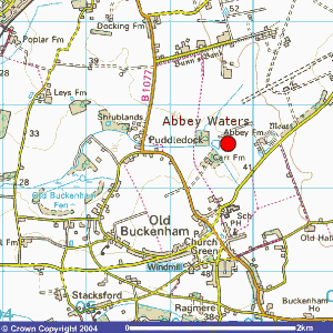
Directions to Abbey Waters, NR17 1NN
From Norwich on the A11
Once you have past Wymondham you will come to a Mr D’s Dinner and a petrol station. Take the slip road just after the garage which is signposted Attleborough & Diss B1077 (there is also a brown tourist sign for Banham Zoo). When at the end of the slip road turn left and continue towards town. The road enters a one way system – stay in the left lane and branch off left, signposted to Diss B1077 (the same direction as the brown tourist signs). After 4 – 5 miles you will see a thick hedge on the left lining the road. Literally as soon as you see the village signs for Old Buckenham look to the left and you will see the entrance to a concrete track with 2 oak gate posts either side - they have red rectangular reflectors on each post. Follow the track down and branch off left across the concrete pad (20 yards before the house) and follow the track to the left. You will see a grassy bank to the right the car park is situated behind the bank. The lake is opposite the car park and up the slope. Please note that this venue is on private farmland - anglers are only permitted on site on match dates that are booked in with this office.From Thetford on the A11
Travel towards Norwich for approx. 11 miles and turn left at Shropham / Quidenham / Eccles signpost and turn left again at T-Junction towards Quidenham / Eccles and stay on this road for approx. 4 miles into Buckenham, at T-Junction turn left past The Gamekeeper Pub, after 300 yards turn right to a concrete track with 2 oak gate posts either side - they have red rectangular reflectors on each post. Follow the track down and branch off left across the concrete pad (20 yards before the house) and follow the track to the left. You will see a grassy bank to the right the car park is situated behind the bank. The lake is opposite the car park and up the slope. Please note that this venue is on private farmland - anglers are only permitted on site on match dates that are booked in with this office.Online Map:
A map of Abbey Waters’ location is below, or view any of the online maps via the links:

Image produced from the Ordnance Survey Get-a-map service. Image reproduced with kind permission of Ordnance Survey and Ordnance Survey of Northern Ireland.


